Showing posts with label volcano. Show all posts

Thursday, June 11, 2009

SoFoBoMo: DONE!


I finished my book!

True, the layout is very simple, and there aren't any nifty interactive features, video, music, or that sort of thing, but since it's my first book, I don't mind that.

I may go back and create another version that includes actual photo essays, but for a first book, I'm pretty happy with this effort, because I succeeded, a day early.

For those of you who take the time to check my book out, I hope you enjoy it!

Monday, May 25, 2009

SoFoBoMo: Loowit


This was my first sight of the mountain, from the Silver Lake visitors' center. It was also the first time I had a chance to see it with that much snow.


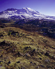
This is the view from the Hofstadt Bluffs visitors' center. I wish there had been some clouds in the sky, but with nature photography you have to work with what nature gives you.

I find the new spring leaves on the stands of forest growing atop the landslide debris in the Toutle River Valley makes for a striking contrast amidst the devastation. The evening light gave their foliage a soft glow, and the snow covering the shattered stratovolcano gave it an air of peace and tranquility.

I also highly recommend the Fire Mountain Grill, at the Hofstadt Bluffs visitors' center. I ate a delicious dinner on their porch while watching this view.


No matter how many times I get a view of this, I suspect that I will never tire of it. I am also planning a Mount Margaret backcountry trip, intent on finding a campsite with a crater view so that I can get some more views of it.


This was my third SoFoBoMo photo safari. I'm now up to 22 images for the book, so I think that I'm making excellent progress, and I have a few slides to get processed as well. Now I just have to start working on the book layout. I'll most likely keep the layout fairly simple for my first crack at making a book. Maybe my second effort will be more ambitious, but that's for another time, after I'm done with this one.

Wednesday, September 24, 2008

Blazing Star


At Lava Beds National Monument, my mother and I hiked to the summit of Schonchin Butte, the one cinder cone in the monument that you're allowed to hike on. There is a fire lookout station at the top of the 700-foot-high butte, but there was no ranger on duty when we made the trip.

The view from the summit is impressive. You can see Mount Shasta quite clearly from there, as seen in this photograph. In this view, you can also see some of the Medicine Lake Volcano, which has an enormous 800-square-mile footprint, but not that much height, only around 4000 feet.


And here is an exmple of a blazing star (Mentzelia laevicaulis).


The summit of this cinder cone is pretty incredible. On the one hand, it's not much but a pile of tephra and pumice with a huge lava flow originating at its base, but at the same time, it has a surprising amount of vegetation on it. And yet, to the northeast, you can see the Tule Lake National Wildlife Refuge alongside the fertile farmlands of Tule Lake.

Sunday, September 14, 2008

Newberry National Volcanic Monument

We stopped at the Lava Lands visitor center on the way back up north from Klamath Falls. It ended up being a very worthwhile stop, even though we didn't have time to explore the whole place; I've heard that Benhma Falls, a direct result of the lava flow here, is very picturesque. This flow is from a parasitic cinder cone, formed on the flanks of the volcano whose summit lies nearly 20 miles southeast. Yes, it's a huge volcano, occupying close to 500 square miles, and littered cinder and spatter cones.

The Lava Lands visitor center is near Lava Butte, which also has a road leading to its summit, with a trail circumnavigating the summit crater, as well as a paved trail meandering through a small section of the lava flow.

These shots are definitely record shots. The light was pretty harsh when we were there in the middle of the afternoon with a nearly cloudless sky.

Here is an image showing part of the lava field, with the Mount Bachelor and the Three Sisters on the horizon.


In the next image, the forked tree trunk in the foreground is framing Mount Bachelor. The other mountains are the Three Sisters, with Broken Top in the foreground.


The final image is of a bush that I have not yet identified, growing in the lava bed, with the same set of mountains in the background.

Thursday, June 19, 2008

Mount Saint Helens

We left Seattle at midnight, at the very end of Triskadekaphobia Day, also known as Friday the 13th. When we arrived at around 3am, the sky was very dark, and we marvelled at the intensity of the stars, the fact that we could clearly see the Milky Way while we put on our hiking boots and all that. The sky lightened quickly though, so we didn't get very many star shots.

The sky was very clear, as we were above the thick clouds in the valleys. By the pre-dawn light, we could see the dense layer of clouds that filled the north fork of the Toutle River Valley; normally an expanse of desolation five miles wide, this time it looked like a sea of clouds.

Tuesday, February 12, 2008

Mount Saint Helens


A view of Mount Saint Helens, showing the crater and the lava dome. The large hunks of rock in the foreground are the hummocks, parts of the summit deposited along the Toutle River Valley during the landslide that occurred during the eruption in 1980. This was from my second trip to Mt. Saint Helens; on my first trip, the cloud cover obscured the crater the entire time I was there.